
Претраживање
Приказ резултата 31-40 од 86
Application of multi-criteria analysis and GIS in ecotourism development (Case study: Serbian Danube region)
(Beograd : Srpsko geografsko društvo, 2015)
Ecotourism can be defined as responsible travel to natural areas that conserves the environment and cultural heritage and improves the well-being of local people. Sustainable planning and management of ecotourism development ...
Environmental risk assessment of radioactivity and heavy metals in soil of Toplica region, South Serbia
(Springer, Dordrecht, 2018)
Activity levels of natural and artificial radionuclides and content of ten heavy metals (As, Cd, Co, Cr, Cu, Mn, Ni, Pb, Zn and Hg) were investigated in 41 soil samples collected from Toplica region located in the south ...
Determinacija potencijala obnovljivih izvora energije na teritoriji opštine Štrpce
(Smederevo : Lokalni ekološki pokretBeograd : Univerzitet u Beogradu - Geografski fakultet, 2018)
Rad prikazuje mogućnosti korišćenja obnovljivih izvora energije na teritoriji opštine Štrpce. Opština Štrpce predstavlja jednu od najjužnijih opština na teritoriji Srbije. Zaštita životne sredine i koncept održivog razvoja ...
A GIS-based method for analysis of a better utilization of thermal-mineral springs in the municipality of Kursumlija (Serbia)
(Pergamon-Elsevier Science Ltd, Oxford, 2018)
There are about 240 geothermal occurrences with 60 commercial spas included in, which are spread throughout the territory of Serbia. The majority of springs and other surface manifestations are located along the southeastern ...
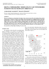
Digital topographic modelling in case with higher flood in the municipality Obrenovac
(Univerzitet u Prištini - Prirodno-matematički fakultet, Kosovska Mitrovica, 2018)
The town of Obrenovac is situated near the banks of three rivers, the Sava River, the Kolubara River and the Tamnava River. It looks like a modern town, though it has often developed in an unplanned manner. This causes ...
GIS analysis of dissipation time of landscape in the Devil's city (Serbia)
(Berg Fac Technical Univ Kosice, Kosice, 2015)
The Devil's City is a unique geomorphological site well known regarding strangely sculptured stony pillars or soil (clayey) pyramids, abandoned mines and two rare hydrologic occurrences. The present landscape is partly ...
Evaluation of the tourist potential and natural attractivity of the Lukovska Spa
(Elsevier, Amsterdam, 2017)
There are, in Serbia, 240 geo-thermal areas, of which 60 host commercial spas. Most are found in the southern edge of the Pannonian Basin in the west and south-east of the country. Of these, the highest and one of the more ...
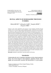
Spatial aspects of demographic processes in Serbia / Prostorni aspekti demografskih procesa u Srbiji
(Beograd : Institut društvenih nauka - Centar za demografska istraživanja, 2018)
Changes in the trends, distribution and structures of the population identified through censuses (such as the changes in total population, gender, educational, age and other structures) are crucial for understanding spatial ...
Kartografska generalizacija za potrebe izrade zidne karte razmere 1:250.000 / Cartographic generalization for wall map production at scale 1:250.000
(Beograd : Univerzitet u Beogradu - Matematički fakultet, 2021)
Kartografska generalizacija je kreativni proces apstrakcije, koji se koristi prilikom izrade karata.
Uključuje proučavanje geografskog okruženja, procenu i obradu geo-podataka u odnosu na vrstu, namenu i
razmeru karte. ...
Application of GIS in assessing natural conditions for the development of raspberry growing at the territory of the municipality of Štrpce
(Novi Sad : Univerzitet u Novom Sadu - Prirodno-matematički fakultet, Departman za geografiju, turizam i hotelijerstvo, 2018)
The paper presents the analysis of natural conditions for the development
of the agricultural branch – raspberry growing in the municipality of Štrpce. The following
analyses were carried out using GIS technology: the ...